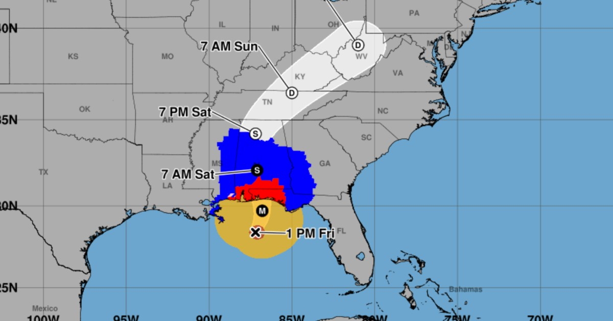
Tropical storm conditions associated with Hurricane Isaias began to be reported on Friday along the northern coast of the Gulf of Mexico, as confirmed by the intermediate bulletin 12A from the National Hurricane Center of the United States (NHC), corresponding to 2:00 p.m. in Miami (1:00 p.m. in the Central Time Zone).
The agency reported a wind gust of 76 km/h in Dauphin Island, Alabama, one of the first concrete measurements of the cyclone's effects in this update. This local record should not be confused with the maximum sustained winds of Isaias, which remain at 195 km/h.
The center continues over the Gulf, but its winds are now reaching the coast
At 2:00 p.m. in Miami, Isaias maintained a category 3 status on the Saffir-Simpson scale. Its center was located about 235 kilometers south of Pensacola, Florida, moving north-northeast at 26 km/h, with an estimated minimum central pressure of 959 millibars.
Tropical storm-force winds extended up to 335 kilometers from the center, while hurricane-force winds reached up to 55 kilometers. These are maximum distances, not uniform radii around the system, and they explain why the effects can be felt on the coast before the center arrives.
The NHC continued to forecast that Isaías would approach the northern Gulf coast during the afternoon and would make landfall Friday night within the hurricane warning area, with hurricane strength or close to it. The exact point and time of landfall were not confirmed.
CiberCuba had previously reported on the expected arrival of Isaías in the northwest of Florida. The new information in advisory 12A is that tropical storm conditions have already begun in coastal areas, and a gust has been reported on Dauphin Island.
Hurricane and storm surge alerts continue
The NHC update did not change the existing alerts. The hurricane warning remains in effect from Ocean Springs, Mississippi, to the boundary between Bay and Gulf counties in Florida. The storm surge warning is also still active from the mouth of the Mississippi River to the Suwannee River in Florida.
Between the Alabama and Florida border and Grayton Beach, the NHC forecasts that the storm surge flooding could reach between 1.8 and 2.7 meters above normally dry land in some areas, if the peak of the surge coincides with high tide. This estimate refers to the potential flood level and not to wave height.
Additionally, hurricane-force winds could penetrate about 160 kilometers inland in southern Alabama. By the weekend, between 100 and 200 millimeters of rain are expected in the southern part of that state, northwest Florida, and southwest Georgia, with local accumulations reaching up to around 380 millimeters. The NHC also warns of possible flooding and tornadoes.
In its 2:00 p.m. advisory from Miami, the NHC urged for the prompt completion of preparations in light of the potentially deadly storm surge and destructive winds. People in the affected areas should follow the NHC's updated advisories and the instructions of local authorities, including any applicable evacuation orders.
Related videos:
Filed under: