
Related videos:
The cyclonic system Humberto, which as of Thursday was a tropical storm in the open waters of the central Atlantic, strengthened during the early hours of Friday and reached hurricane status, becoming the third of the active 2025 hurricane season.
According to the bulletin from the National Hurricane Center (NHC), at 5:00 AM, the eye of Humberto was located at 22.2°N and 57.3°W, about 465 miles (750 km) northeast of the Northern Leeward Islands.
Its maximum sustained winds reached 75 mph (120 km/h), with stronger gusts, and it is slowly moving northwest at just 3 mph (6 km/h).
The NHC warned that the system will continue to strengthen in the coming hours and could become a major hurricane over the weekend.
Currently, hurricane-force winds extend up to 10 miles (20 km) from the center.
In a message posted on , Cuban meteorologist Jorge Félix Hernández confirmed the intensification of the phenomenon.
"Humberto has just become the third hurricane of the 2025 Atlantic hurricane season. It is forecasted to strengthen into a powerful hurricane in the coming days. For now, it is only a concern for navigation in the region," he said.
Context of high cyclonic activity in the Atlantic
Humberto's strengthening occurs in the midst of a particularly active situation in the Atlantic.
On Thursday, the NHC was also monitoring two other systems: Hurricane Gabrielle, which is rapidly moving east and poses a direct threat to the Azores, and an active tropical wave in the central Caribbean with a high probability of becoming the next named storm, Imelda.
According to reports, Gabrielle remains a category 1 hurricane, with winds of 140 km/h, and is expected to hit the Azores archipelago between Thursday night and Friday morning, causing heavy rainfall, destructive winds, and storm surges.
For its part, the system identified as AL94 -which would be named Imelda if it becomes a tropical storm- has begun to generate rain and thunderstorms over the Dominican Republic and the Turks and Caicos Islands.
Specialists estimate a 70% likelihood that it will develop into a tropical cyclone in the next 48 hours, rising to 90% within seven days.
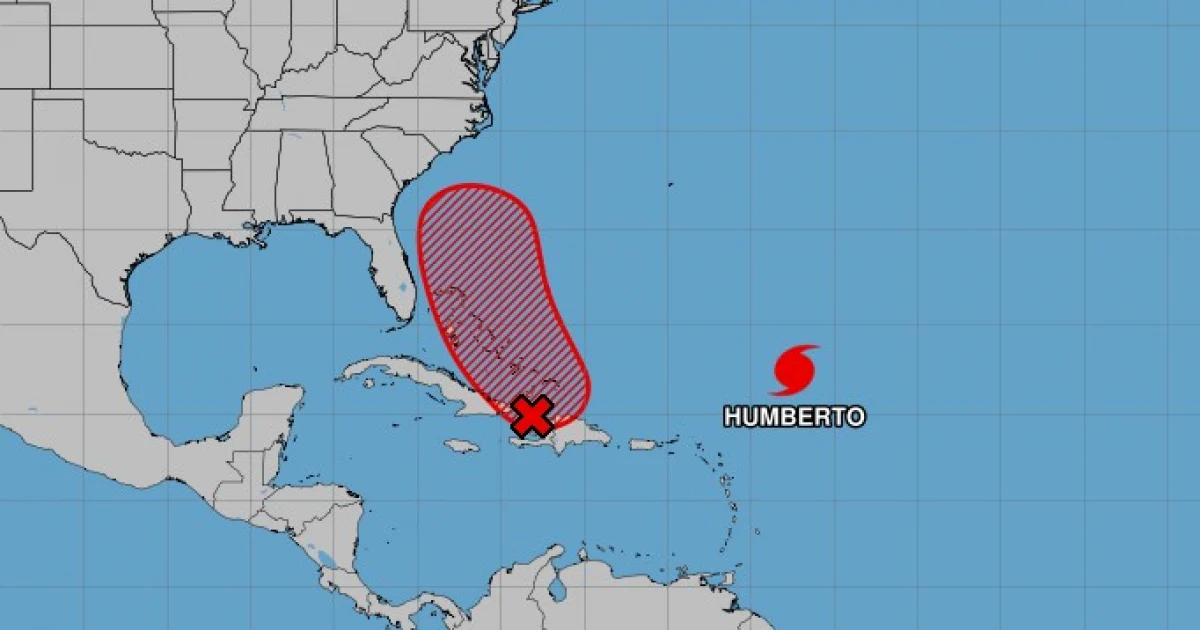
Tropical wave and its possible effects on Cuba
Although Humberto is moving over open sea and does not pose an immediate threat to the Caribbean, the focus in Cuba is on the development of the tropical wave that is forming in the eastern Caribbean and could develop into Tropical Storm Imelda.
The Meteorological Institute (INSMET) issued a special alert on Thursday, warning that heavy rains and thunderstorms are expected from Camagüey to Guantánamo starting Friday, September 26, and continuing through the weekend.
According to the statement, the rainfall could be intense in some areas in the eastern part of the country due to high humidity and the proximity of the system.
Meteorologists insist that communities in the region must remain vigilant and closely monitor official reports, as the hurricane season is currently at its most active phase, and the formation of several simultaneous phenomena in the Atlantic increases risks for the Caribbean islands and the southeastern coast of the United States.
Frequently Asked Questions about the 2025 Hurricane Season in the Atlantic
What category has Hurricane Humberto reached?
Hurricane Humberto has reached hurricane category with maximum sustained winds of 75 mph (120 km/h). It was the third hurricane of the 2025 cyclone season, strengthening from a tropical storm in the central Atlantic. It is expected to continue strengthening in the coming hours.
What is the expected path for Hurricane Humberto?
Humberto is moving slowly to the northwest at a speed of 3 mph (6 km/h) and is located about 465 miles (750 km) northeast of the northern Windward Islands. It does not pose an immediate threat to the Caribbean, but it is of interest for navigation in the region.
What other cyclonic phenomena are active in the Atlantic?
In addition to Hurricane Humberto, Hurricane Gabrielle and a tropical wave in the central Caribbean are under watch. Gabrielle threatens the Azores with hurricane-force winds, while the tropical wave could develop into Tropical Storm Imelda, potentially impacting eastern Cuba and other areas of the Caribbean.
What impact could the tropical wave have on Cuba?
The tropical wave in the Caribbean could generate heavy rains and thunderstorms in eastern Cuba from Camagüey to Guantánamo. The Institute of Meteorology of Cuba has issued a special alert due to high humidity and the proximity of the system, urging communities to remain vigilant.
Filed under: