
The National Hurricane Center (NHC) is monitoring two developing systems in the Atlantic that could become tropical depressions in the coming days.
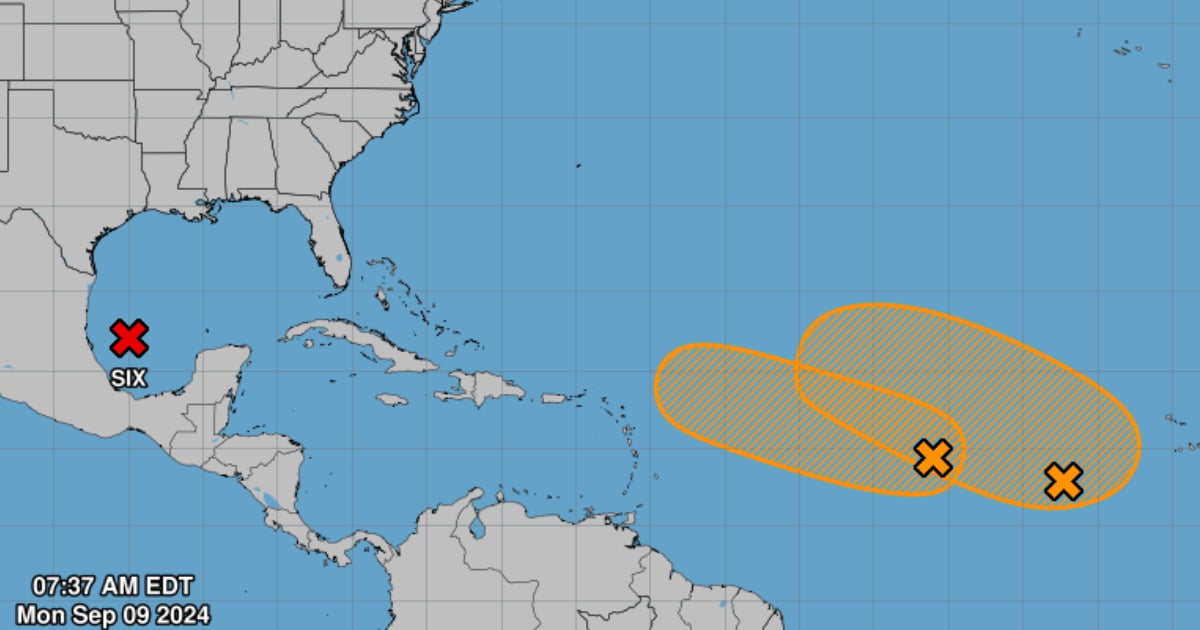
The first area of low pressure is located in the central tropical Atlantic and is generating disorganized rains and thunderstorms, reported the NHC on its website.
However, it warned that the environmental conditions are moderately favorable for its development, with a 60% chance of formation in the next 48 hours and over the next 7 days.
Additionally, it was emphasized that this system is expected to move west-northwest at a speed of 10 mph as it evolves over the next few days.
The NHC is also monitoring another low-pressure area located several hundred miles west-southwest of the Cape Verde Islands, which is producing a broad area of disorganized rain and thunderstorms.
In this case, the monitoring center warned that the system will interact with a tropical wave in the coming days, which could promote its development.
Although the chances of development in the next 48 hours are low (close to 0%), they increase to 60% over the next 7 days as the system moves west-northwest at a speed of 10 to 15 mph.
Currently, the NHC is monitoring Potential Tropical Cyclone Six, located in the southwest Gulf of Mexico, which has a high chance of formation in the short term, with a 90% chance of becoming a tropical depression in the next 48 hours and a 90% chance in the next 7 days.
This weather system could hit the coasts of the states of Texas and Louisiana by midweek.
In recent days, five disturbances were identified in the North Atlantic, the Caribbean Sea, and the Gulf of Mexico, which, although with low chances of development, indicated the approach to the peak stage of the current hurricane season.
According to the forecast from the National Oceanic and Atmospheric Administration (NOAA), during the current cyclone season, between 17 to 24 named storms (winds of 39 mph or greater) and between 8 to 13 hurricanes (winds of 74 mph or greater) could form.
The entity has considered that the hurricane season has been the most active in the last 30 years in the Atlantic.
What do you think?
COMMENTFiled under: