
The National Hurricane Center (NHC) of the United States warned this Sunday that potential tropical cyclone number six, which is gradually organizing over the southwest Gulf of Mexico, will strengthen to become a hurricane by midweek.
The NHC issued a series of warnings about this weather system, which could strike the coasts of Texas and Louisiana by the middle of the upcoming week.
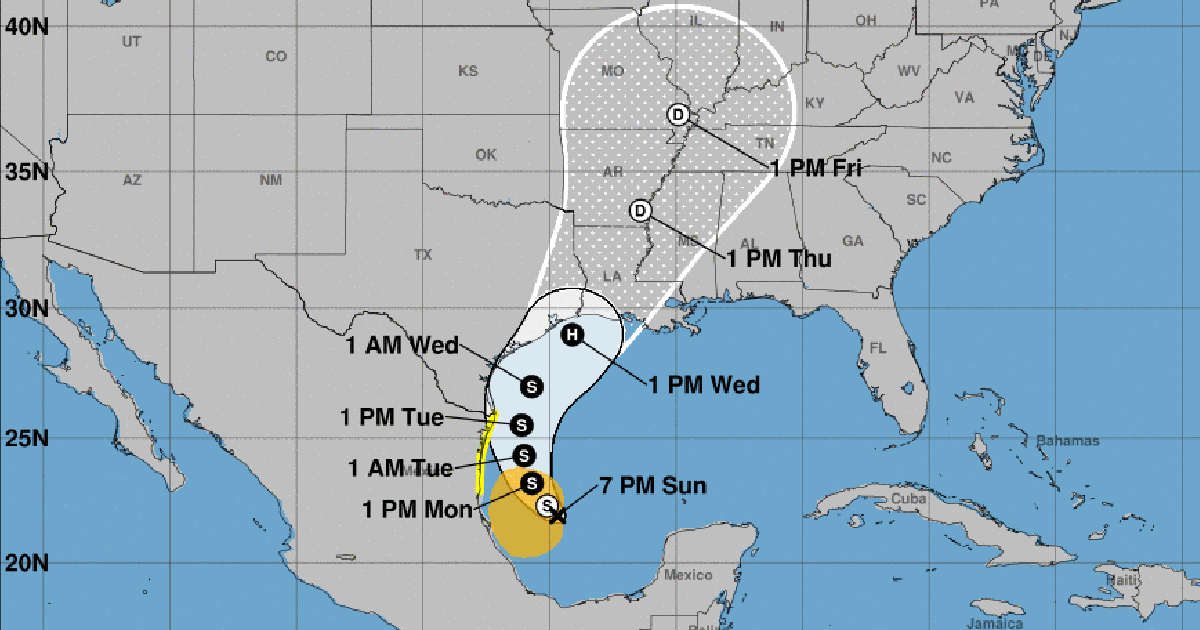
A forecast issued at 7 p.m. this Sunday predicts that "the system will become a tropical storm on Monday, as it moves northwest to north, near or along the western coast of the Gulf of Mexico."
For this reason, tropical storm watch advisories have been issued for part of northeastern Mexico, and if necessary, additional alerts for the southern coast of Texas would be issued tonight, the NHC statement indicated.
Meteorologists also warned that potential tropical cyclone six could become a hurricane before reaching the northwestern coast of the Gulf by midweek.
The NHC warned that, although "it is very early to pinpoint the exact location and magnitude of the impacts, the potential risk of dangerous storm surges and destructive winds threatening people's lives is increasing for the coasts of upper Texas and Louisiana, starting Tuesday night."
According to forecasts, the potential cyclone six is expected to bring heavy rains and a risk of flash flooding from the northeastern coast of Mexico to coastal areas of the mentioned U.S. states until Thursday.
At the beginning of September, the NHC was monitoring the development of three tropical waves that could become tropical depressions in the Atlantic area in the following days.
This week, already at the peak of the hurricane season, experts have been monitoring five disturbances in the North Atlantic, the Caribbean Sea, and the Gulf of Mexico, although they warned that they had low chances of development.
On Thursday, they issued a warning about a low-pressure trough in the northwestern Gulf of Mexico, which was generating disorganized rains and thunderstorms near the coasts of Louisiana and Texas. However, they anticipated that upper-level winds would hinder its development in the coming days due to the approach of a front, and they deemed the formation of a cyclone unlikely.
What do you think?
COMMENTFiled under: