
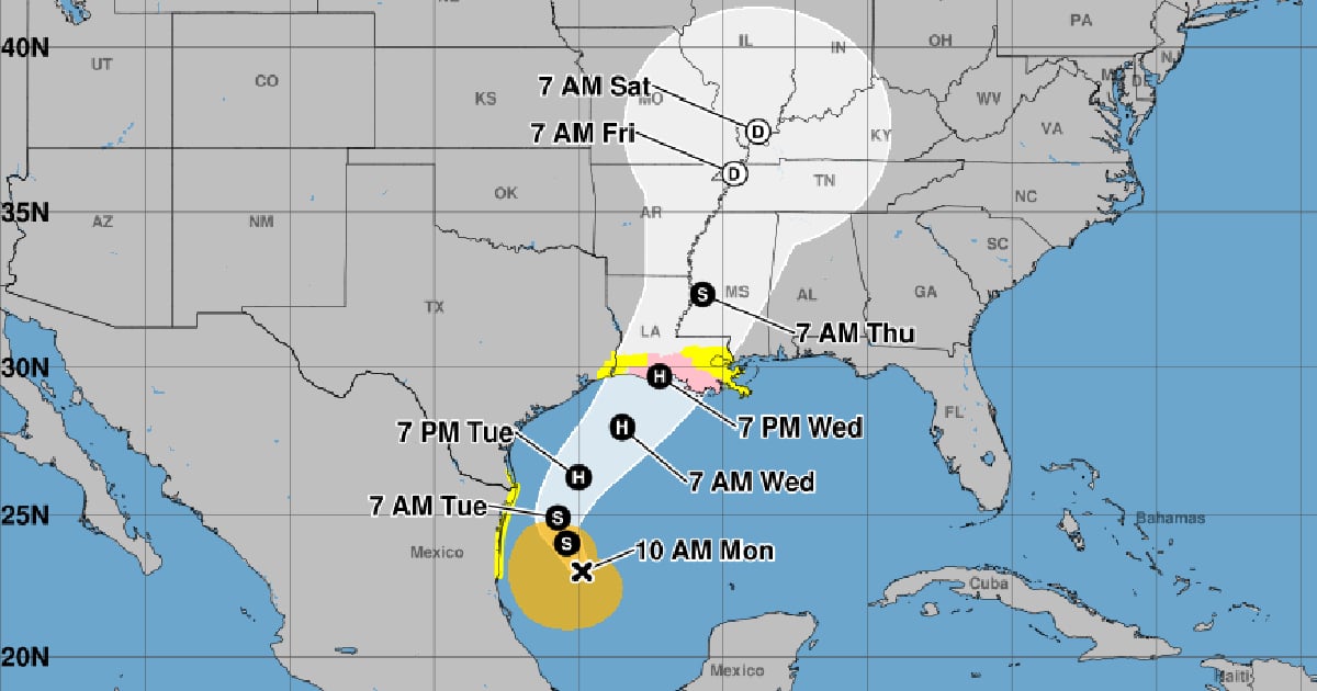
The disturbance that had formed southwest of the Gulf of Mexico became tropical storm Francine on Monday morning, reported the National Hurricane Center (NHC) of the United States.
In its 10 a.m. advisory number 4, the NHC indicated that this cyclonic system is expected to intensify with storm surges and hurricane alerts for parts of the upper Texas and Louisiana coasts, where there is an increasing likelihood of potentially deadly flooding due to storm surges.
The entity predicted that Francine will become a hurricane when it reaches the northwest coast of the Gulf this Wednesday, or that night.
It also warned of the increasing risk of damaging hurricane-force winds in areas of southern Louisiana starting Wednesday, so residents in the watch area should follow the advice of local authorities.
Francine is expected to bring heavy rain and a significant risk of flash flooding along the northeast coast of Mexico, parts of the southern Texas coast, the upper coast of that state, southern Louisiana, and southern Mississippi by Thursday morning, the forecast noted.
At noon on Monday, the Forecast Center of the Meteorology Institute (INSMET) of Cuba reported that during the morning, the area of low pressure located southwest of the Gulf of Mexico "showed a well-defined circulation" and became Tropical Storm Francine.
Cuban meteorologists assured that this tropical system poses no danger to the island.
The day before, the NHC warned that the potential tropical cyclone number six of the current hurricane season was gradually organizing over the southwestern Gulf of Mexico and would strengthen to become a hurricane by midweek.
Experts warned that this system would generate potentially dangerous storm surges for people's lives and hurricane-force winds along the coasts of Louisiana and the upper part of Texas by mid-week.
Similarly, the National Hurricane Center also announced on Monday that it is monitoring two developing systems in the Atlantic that could become tropical depressions in the coming days.
The first area of low pressure is located in the central tropical Atlantic and is generating disorganized rain and thunderstorms. However, the NHC warned that environmental conditions are moderately favorable for its development, with a 60% chance of formation within the next 48 hours and the coming seven days.
The other low-pressure area is located several hundred miles west-southwest of the Cape Verde islands and is producing a broad area of disorganized rain and thunderstorms. This system will interact with a tropical wave in the coming days, which could enhance its development.
U.S. meteorologists consider that the 2024 hurricane season has been the most active in the last 30 years in the Atlantic.
What do you think?
COMMENTFiled under: