
The Institute of Meteorology of Cuba (INSMET) issued a early warning notice on Monday due to the likelihood of heavy rains in the west and center of the country.
The cause is the potential tropical cyclone formed in the northwest Caribbean Sea, where a wide area of low pressure persists, associated with an extensive area of clouds with showers, rain, and thunderstorms, which has organized better in the last 12 hours.
The Pinar del Río Forecast Center reported that from Tuesday to Thursday, accumulations between 150 and 200 mm of rain are expected in most of the province, which could exceed 300 mm in the westernmost part.
In addition, there is a high probability of flooding in low-lying areas.
According to INSMET, in the coming days the conditions will be favorable for the formation of a depression or tropical storm, as the area of low pressure moves through the northwest Caribbean Sea and the southeast Gulf of Mexico.
"Regardless of the development and trajectory of that system, it is expected that in the coming days, there will be numerous rainfall in the western and central regions of Cuba, which will become strong and intense in some localities starting from the evening of Tuesday, the 24th," the note specifies.
Depending on the path of the system, wind strength may also increase and coastal flooding may occur in the southern part of the western region.
Although for now the heavy rains are the most dangerous element, strong winds with tropical storm intensity (greater than 62 km/h) can occur as the phenomenon moves north through the Yucatán Channel or near the tip of Pinar del Río, possibly becoming a depression or tropical storm.
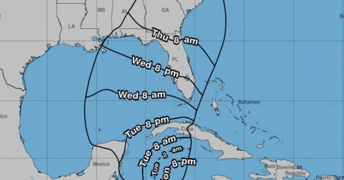
The National Hurricane Center (NHC) announced the formation of possible tropical cyclone number nine of the season in the Caribbean Sea, which could become a hurricane on Wednesday morning.
The agency issued alerts and warnings for tropical storm conditions for parts of western Cuba and the northeast of the Yucatán Peninsula in Mexico.
At 11:00 am on this Monday, the system was located 130 miles south-southwest of Grand Cayman and 350 miles southeast of the westernmost point of Cuba. It was moving north at 6 mph with maximum sustained winds of 30 mph.
It is estimated that the disturbance will strengthen and will be close to becoming a hurricane when it reaches the Caribbean Sea on Tuesday night.
What do you think?
COMMENTFiled under: