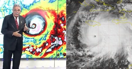
The latest weather report issued by Canal Caribe on the morning of this Monday, October 27, confirmed that Hurricane Melissa reached category 5, the highest on the Saffir-Simpson scale, with sustained winds of 260 km/h and a central pressure of 917 hectoPascals.
However, the television report adopted a surprisingly calm tone, which contrasts with the extreme danger warnings issued by the National Hurricane Center (NHC) of the United States.
During the broadcast, Cuban meteorologist Ariel Maturel explained that Melissa remains "well organized" south of Jamaica, moving slowly westward at just 6 km/h, in an area where the directional currents are weak.
This slowness, he warned, increases the risk of heavy rains and prolonged swells over eastern Cuba, although the national report did not emphasize this danger.
According to the television report, the highest probability of a direct impact from the center of the hurricane is currently over Santiago de Cuba, with the system also possibly affecting Guantánamo and Granma between Tuesday and Wednesday.
The meteorologist indicated that, after interacting with the mountains of Jamaica, the cyclone could "weaken a bit," although he acknowledged that once it moves back over the sea, "it could regain strength just before reaching the south of Cuba."
Despite these technical warnings, the report concluded by emphasizing that "the rest of the country will experience partial cloudiness and little change in the weather," even wishing for "an excellent day and that good weather accompanies you," which contradicts the severity of the regional scenario.
Meanwhile, the NHC and international organizations emphasize that Melissa poses a potentially catastrophic threat to eastern Cuba, where coastal flooding, strong swells, and mass evacuations are already being reported in municipalities such as San Antonio del Sur and Maisí.
Filed under: