The renowned Cuban meteorologist José Rubiera has recently returned to national television with an urgent warning about the approach of Hurricane Melissa towards Cuban territory.
In a special broadcast on the National Television News (NTV), the specialist urged maximum attention and preparation in light of the imminent impact of the phenomenon.
“One must be very aware when crossing Jamaica, because the distance between Jamaica and Cuba is only 12 hours”, warned Rubiera.
Hurricane Melissa, which is already shaping up to be one of the most intense events of the season, could impact areas of southeastern Cuba between Tuesday night and Wednesday morning.
"We must protect human life, which is the most valuable; material things can be rebuilt, but human life cannot," he emphasized.
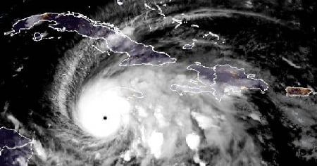
A well-organized and far-reaching hurricane
The meteorologist also described the structural characteristics of the system: “A completely circular eye, bands of clouds with heavy rain and winds, and then the spiral bands that carry rain to distant places, such as the Dominican Republic and Haiti, which will continue to experience intense rainfall.”
Jamaica, for its part, has already been experiencing the effects of Melissa for several days, with an increase in the intensity of the associated phenomena in recent hours.
Rubiera also explained that the hurricane is waiting for "the continental trough that will abruptly push it north and north-northeast and northeast".
According to him, the trajectory cone is already very well defined and the forecast models have aligned.
Winds, rains, and sea: The three dangerous elements
Rubiera insisted that citizens should not focus solely on the path of the eye of the hurricane, as an event of this magnitude carries multiple threats.
“A hurricane is not a point, but a large area where there are hurricane-force winds, heavy rains, storm surges, and all sorts of hazardous elements associated with the hurricane,” he explained.
In this regard, he recalled that the three most dangerous elements of a hurricane are: "the winds, the rains, and the sea," and that human life must always be the priority.
According to Rubiera's forecast, Melissa is expected to arrive in Jamaica by dawn on Tuesday.
Although it is expected that its intensity will decrease slightly due to interaction with the mountainous geography of that island, it would still emerge from there as a major hurricane.
"It may slightly decrease in strength, but it should still emerge as a powerful hurricane, category 3 or 4, possibly not category 5," he clarified.
However, she warned that even at a category 3 or 4, Melissa will still be extremely dangerous and "will have enough destructive power."
Expected impact in Cuba and subsequent evolution
The hurricane is expected to make landfall on the southeastern coast of Cuba between Tuesday night and early Wednesday morning, and then quickly move toward the Bahamas and, subsequently, into the Atlantic, where it would become extratropical.
“It must rapidly cross Cuba, move out to the Bahamas, and then extratropicalize in the Atlantic…” said Rubiera.
During its appearance on NTV, the phenomenon was still at category 4, with sustained winds of 230 km/h. However, within hours it escalated to category 5, reaching winds of up to 260 km/h.
In conclusion, Rubiera described Melissa as a "very dangerous hurricane," whose winds intensified by 95 km/h in just 24 hours.
The meteorologist urged Cubans to act responsibly, stay informed, and prioritize the protection of human life.
The hurricane Melissa continues its slow and devastating path through the western Caribbean, with maximum sustained winds of 260 km/h (160 mph) and a minimum central pressure of 913 millibars, according to the intermediate bulletin issued at 8:00 a.m. (Eastern Time) by the National Hurricane Center (NHC) of the United States.
The cyclone, described by experts as "extremely dangerous," is currently located at a latitude of 16.4°N and a longitude of 78.0°W, approximately 220 kilometers southwest of Kingston (Jamaica) and 515 kilometers southwest of Guantánamo (Cuba).
It is moving slowly west at 6 km/h, but it is expected to turn northwest and north overnight, before accelerating northeast starting Tuesday.
In Cuba, the provinces of Granma, Santiago de Cuba, Guantánamo, and Holguín remain under hurricane warning, while Las Tunas is under tropical storm warning.
The authorities of the Civil Defense have urged to complete emergency preparations before nightfall, in light of the possible arrival of hurricane-force winds and torrential rains in the eastern part of the country starting Tuesday.
Filed under: