The meteorologist José Rubiera warned this Monday that Melissa is now a “gigantic, monstrous Category 5 hurricane” that is approaching Jamaica.
In the latest update on his YouTube channel, the expert warned that after crossing the island between night and dawn, Melissa could be caught by a trough and accelerate toward eastern Cuba as a powerful cyclone —possibly category 4 or 3— between Tuesday night and Wednesday morning.
“It is extremely dangerous,” he emphasized, after specifying that the system has a small eye, maximum sustained winds of 270 km/h and gusts exceeding 300 km/h, with the center located about 200 kilometers southwest of Kingston.
Rubiera described Melissa as a “practically perfect” hurricane in its structure: an eye measuring 16 kilometers in diameter, intense convective activity, and an organization that has solidified after reaching category 5 in the early morning.
Due to its slow movement in the coming hours over Jamaica, it anticipated catastrophic damage on that island; afterward, with the arrival of the trough, the system will gain translational speed towards the eastern provinces of Cuba, where its crossing is expected to occur between Tuesday night and Wednesday morning before moving out to sea and continuing towards the eastern Bahamas, already with some weakening by Thursday.
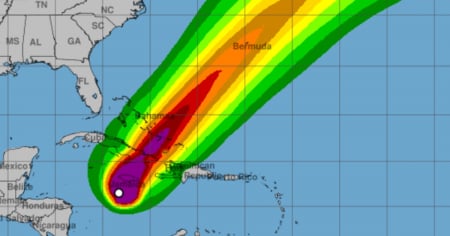
Regarding the trajectory, he noted that the numerical models now exhibit a remarkable alignment over eastern Cuba, consistent with the official cone from the National Hurricane Center.
Nevertheless, he requested not to "follow the middle line" because the hurricane is not a point: a small shift in the track moves the entire wind field and can bring hurricane conditions further west, even up to Camagüey, while the tropical storm winds — which are also damaging — extend much farther than the circulation of the eye.
Rubiera insisted that the rain will be very dangerous, with urban and rural flooding and landslides in hillside areas.
He also recalled that hurricanes can indeed produce lightning and tornadoes within their spiral bands and warned about the storm surge along the coasts, with elevated sea levels and violent waves rendering the entire exposed coastal strip impassable.
He also emphasized that winds increase on the upper floors of buildings and in elevated areas such as hills and mountains, urging people to seek sturdy structures or safe shelters.
In light of Eastern Cuba, the specialist requested that preparations be finalized in areas under cyclone alert and that saving lives be the priority, while Jamaica is facing the severe impact of the hurricane starting tonight due to its slow movement.
"It is important to prepare very well", he concluded, indicating that there will be new updates with more details as the accelerated course towards the Cuban archipelago is confirmed.
In a special segment broadcasted by the National Television News (NTV), the specialist had called for maximum attention and preparedness in anticipation of the imminent impact of the phenomenon.
Hurricane Melissa, which is already shaping up to be one of the most intense events of the season, could impact areas of southeastern Cuba between Tuesday night and early Wednesday morning.
The event has already reached 280 km/h this Monday and is now located at a latitude of 16.4°N and a longitude of 78.0°W, which means it is approximately 220 kilometers southwest of Kingston (Jamaica) and 515 kilometers southwest of Guantánamo (Cuba).
Filed under: