
Related videos:
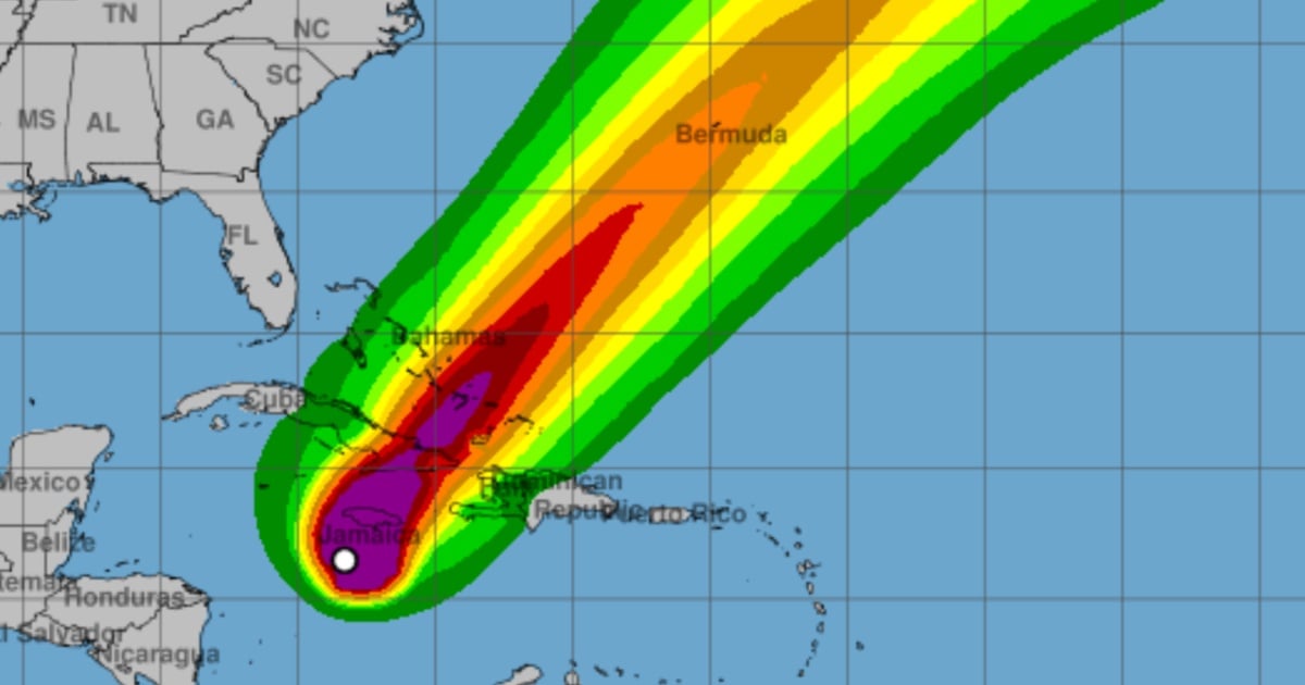
The National Hurricane Center (NHC) reported on Monday afternoon that Melissa maintains maximum sustained winds of 175 mph (280 km/h), a central pressure of 906 mb, and continues as a category 5 hurricane, moving very slowly to the northwest.
In its latest report, the NHC states that the eye was located at 16.7°N, 78.4°W, approximately 140 miles (225 km) southwest of Kingston, Jamaica, and 320 miles (515 km) southwest of Guantánamo, Cuba.
The NHC warns that catastrophic winds that threaten life, flooding, and storm surge are imminent in Jamaica between tonight and Tuesday.
The core of the system will move near or over Jamaica during that time, crossing the southeast of Cuba on Tuesday night and will continue over the southeast or central Bahamas on Wednesday, while gradually turning north and then northeast, and speeding up between Tuesday and Thursday.
Despite possible fluctuations in intensity before making landfall in Jamaica, the official forecast keeps Melissa as an extremely powerful major hurricane as it approaches Jamaica and southeastern Cuba, and still with hurricane strength during its passage through the Bahamas.
The alerts and warnings currently in effect reflect the seriousness of the situation: Hurricane warning for Jamaica; for the Cuban provinces of Granma, Santiago de Cuba, Guantánamo, and Holguín; and for the southeast and central Bahamas.
A hurricane watch is in effect for the Turks and Caicos, and a tropical storm warning is in place for Haiti, Las Tunas (Cuba), and the Turks and Caicos.
On land, preparations must be complete in Jamaica and rushed to completion in the areas under alert in Cuba, the report emphasizes.
The wind radius confirms the great magnitude of the cyclone: hurricane-force winds extend 30 miles (45 km) from the center, and tropical storm winds reach up to 195 miles (315 km).
The NHC also details an extreme danger due to rainfall: 15 to 30 inches in Jamaica with localized maxima of up to 40 inches along with additional contributions of 6 to 12 inches in the south of Hispaniola; for eastern Cuba, 10 to 20 inches are expected, with peaks of 25 inches between Monday and Wednesday, capable of causing flash floods that threaten lives and numerous landslides.
In the Bahamas, the expected accumulation is 5 to 10 inches on Tuesday and Wednesday.
The storm surge will be another critical component. On the southern coast of Jamaica, the NHC forecasts 9 to 13 feet above ground level, with large and destructive waves; on the northwestern coast of Jamaica, 1 to 3 feet.
For the southeast coast of Cuba, the potential for significant storm surge reaches 7 to 11 feet by late Tuesday or Wednesday, and in the Bahamas and Turks and Caicos, 4 to 6 feet above normally dry land is possible.
The waves and dangerous ocean currents will spread across Hispaniola, Jamaica, eastern Cuba, and the Cayman Islands, and later to the Bahamas, Turks and Caicos, and Bermuda.
The NHC reiterates that this is a high-impact event and that interests in Bermuda should also monitor its progression.
Filed under: