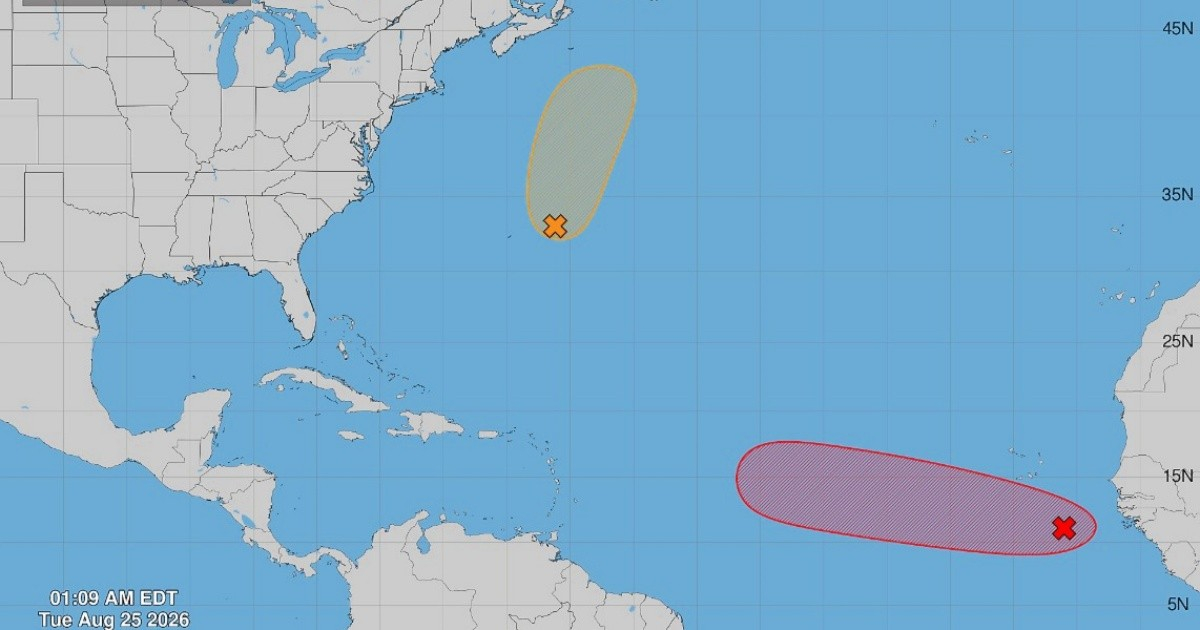
The National Hurricane Center (NHC) in Miami issued its 2:00 a.m. EDT bulletin this morning, tracking two tropical disturbances in the Atlantic.
One of them is receiving special attention due to its potential development as it moves across the ocean, although there is currently no official trajectory towards Cuba or Florida.
AL96: The system that needs to be monitored
The disturbance that is under the most scrutiny is AL96, a low-pressure area located a few hundred miles south-southeast of the Cape Verde islands in the eastern tropical Atlantic.
According to the bulletin from the NHC, "the environmental conditions appear favorable for gradual development, and this system is likely to become a tropical depression in the coming days as it moves west and west-northwest across the eastern and central tropical Atlantic."
The chances of cyclonic formation are significant: 60% in the next 48 hours and 70% in the next seven days.
The agency classifies the likelihood of formation within seven days as high.
Nevertheless, the NHC warns that "environmental conditions could become less favorable for its development by the end of the weekend," which introduces uncertainty regarding its evolution in the medium term.
The system is moving west and west-northwest across the tropical Atlantic, although there is still no official trajectory towards Cuba or Florida.
Its evolution and trajectory will need to be monitored in the coming days to determine whether it could subsequently approach the Caribbean, the Bahamas, or the southeastern United States.
A significant event originating in the eastern Atlantic was Hurricane Irma in 2017, which made landfall in Cuba on September 9 and impacted Florida the following day.
However, the geographical origin of a cyclone does not allow for anticipation of its trajectory, so the development of AL96 will depend on the atmospheric conditions in the coming days.
AL95: lesser threat and distant trajectory
The second disturbance under watch is AL95, in the central subtropical Atlantic, a few hundred miles east-northeast of Bermuda, moving north at a speed of 24 to 32 km/h.
The NHC considers its development outlook to be less favorable: "recent wind data obtained through scatterometer indicate that the circulation center is broad and elongated, while the associated rainfall activity remains disorganized."
Regarding its immediate evolution, the agency states that “this system could still develop into a tropical depression or a short-lived tropical storm today, before encountering increasingly unfavorable conditions tonight and Wednesday, which would likely end its chances of development.”
Its chances of formation remain at 40% both in 48 hours and in seven days, and due to its trajectory to the north, it does not pose a direct threat to Cuba or Florida.
Cuba enters its peak hurricane risk period
Both systems appear at a critical moment in the weather calendar.
According to Professor Luis Enrique Ramos Guadalupe from the Meteorological Society of Cuba, “the second half of August marks the beginning of the most dangerous cyclone period of the year for Cuba and the rest of the Caribbean.”
Historical records support this warning: between 1791 and 2022, the island was affected by 19 hurricanes in August, accounting for 16% of all hurricanes that impacted it during those 231 years.
The 2026 hurricane season has been unusually calm so far: only three named storms—Arthur, Bertha, and Cristóbal—have formed, and the NOAA predicts a 75% chance that the season will be below normal, influenced by El Niño.
Cuba faces this period with the population still recovering from the hurricane Melissa, which made landfall in the eastern part of the island in October 2025 as a category 3, affecting more than 3.5 million Cubans and damaging over 116,000 homes in Santiago de Cuba, Holguín, Granma, and Guantánamo.
The INSMET forecasts a 40% chance that at least one hurricane will affect the island in 2026, and a 75% probability of impact from a tropical storm.
Related videos:
Filed under: