The Forecast Center of the Institute of Meteorology (INSMET) issued its first notice this Tuesday regarding the Tropical Depression Nine, formed in the Gulf of Mexico, a system that could develop into a hurricane, although it does not currently pose a direct threat to Cuba.
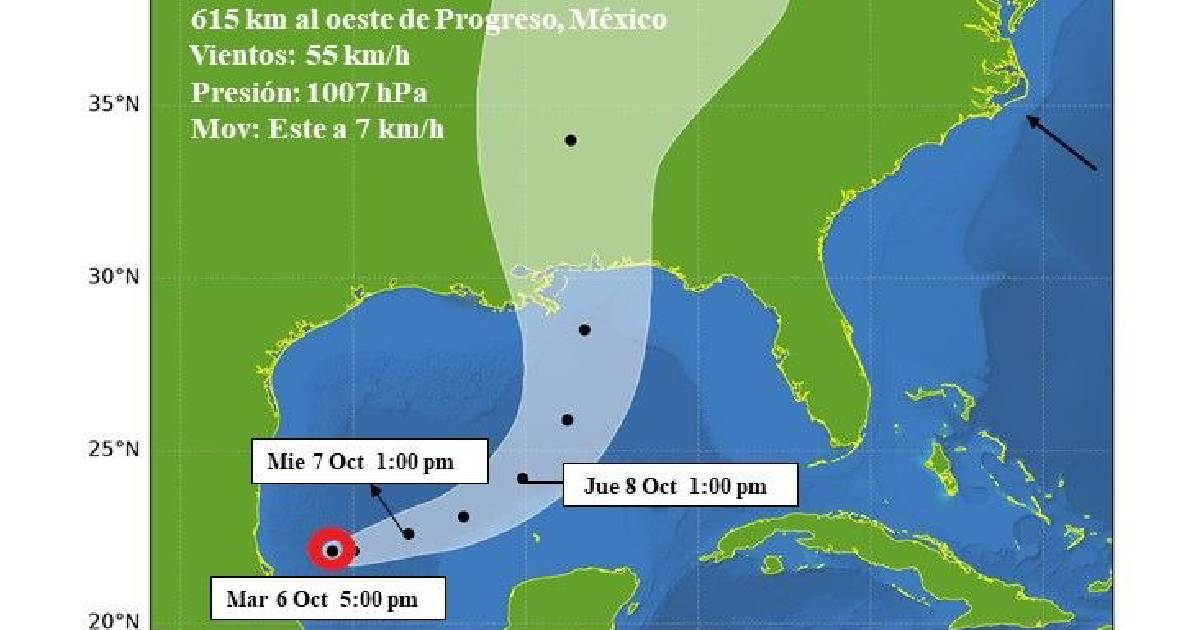
At 5:00 p.m., the center of the depression was located at 22.1 degrees north latitude and 95.6 degrees west longitude, approximately 615 kilometers west of Progreso, Mexico, according to the notice released by INSMET on Telegram.
The system had maximum sustained winds of 55 km/h, with higher gusts, a central pressure of 1,007 hectopascals, and was moving slowly eastward at about 7 km/h, data that matches the first advisory from the National Hurricane Center of the United States (NHC).
INSMET stated that the depression will continue to gain organization and intensity and could become a tropical storm during the early hours of Wednesday.
Upon reaching that category, it would be named Isaias.
The NHC anticipates a sustained strengthening and estimates that the system could reach hurricane status on Thursday. The projected path would take it to pass north of the Yucatán Peninsula that day, and then curve northeast to approach the northern Gulf Coast of the United States on Friday.
For the moment, there are no watches or warnings associated with the system, although the NHC has advised residents of the Yucatán Peninsula and the U.S. Gulf Coast, from Louisiana to the Florida Panhandle, to closely monitor its development.
In coastal areas of the Bay of Campeche, rainfall of between 50 and 100 millimeters could be recorded until Thursday. For the central Gulf coast of the United States, the forecast indicates accumulations of between 75 and 150 mm from Friday through the weekend, with isolated maxima of up to 254 mm, which could cause sudden and urban flooding.
No direct danger to Cuba
INSMET was categorical in its assessment: "This system poses no danger to Cuba."
The NHC also does not list Cuba among the areas that should closely monitor the evolution of the cyclone. The predicted trajectory would take it to pass north of the Yucatán Peninsula that day and then turn northeast to approach the northern Gulf Coast of the United States on Friday.
Tropical Depression Nine emerges in the midst of an exceptionally calm Atlantic hurricane season in 2026. The previous eight named cyclones —Arthur, Bertha, Cristóbal, Dolly, Edouard, Fay, Gonzalo, and Hanna— did not develop into hurricanes.
The situation had so far contrasted with the forecasts released in May by INSMET itself, which estimated a season with 11 tropical cyclones, including five hurricanes.
Although the current system does not pose a direct threat to Cuba, October remains one of the months with the highest cyclonic activity for the Island, which is why meteorologists are keeping a close watch on the Atlantic, the Caribbean, and the Gulf of Mexico.
The NHC will continue to update the track and intensity of Tropical Depression Nine over the next few hours.
Related videos:
Filed under: