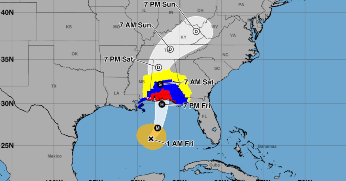
The hurricane Isaías has intensified to reach maximum sustained winds of 165 km/h, equivalent to a category 2, and it could briefly become a category 3 hurricane on the morning of this Friday, October 9th. The National Hurricane Center of the United States (NHC) warns that it will remain a dangerous cyclone as it approaches the northern Gulf Coast.
According to the official advisory number 10 from the NHC, issued at 03:00 UTC on Friday (11:00 p.m. Thursday in Miami), the center of the hurricane was located about 415 kilometers south of the mouth of the Mississippi River. It was moving northeast at 22 km/h, and its minimum central pressure was estimated at 969 millibars.
The forecast indicates the possibility of a Category 3 hurricane
The meteorological discussion number 10 describes an improved organization of Isaias, with signs in the satellite images that it may be forming an eye. Based on the available data, experts have raised the estimated intensity of the cyclone to 90 knots, approximately 165 km/h.
In the track and intensity forecast, the NHC expects a maximum of 100 knots, equivalent to about 115 miles per hour (185 km/h), by 8:00 a.m. on Friday in Miami. This value corresponds to a category 3 hurricane on the Saffir-Simpson scale.
Category 3 is still a forecast, not an observed intensity. The NHC considers it possible for further strengthening in the short term, followed by some weakening due to increased wind shear, meaning the variations in speed or direction with height. However, a potential downgrade in category would not eliminate the threat of storm surge, heavy rainfall, and destructive winds.
Swells of up to 2.1 meters and risk of flooding
In addition to the wind, one of the main dangers is the rise of the sea. The public bulletin from the NHC warns that if the maximum surge coincides with high tide, the water could reach between 1.5 and 2.1 meters above ground level at some points along the coast between Dauphin Island, Alabama, and Indian Pass, Florida. Other coastal areas of Mississippi, Alabama, and Florida are also at risk of dangerous flooding.
For southern Alabama, the northwest of Florida—including the Panhandle and Big Bend regions—and southwestern Georgia, the NHC predicts general accumulations of about 100 to 200 millimeters of rain between Friday and the weekend. In isolated areas, totals could reach approximately 380 millimeters, especially near the border between the Panhandle and Big Bend. These rainfall amounts increase the risk of flash flooding, urban flooding, and river flooding.
The possibility of tornadoes is also being considered from Friday night in parts of Alabama, northwest Florida, and the extreme southwest of Georgia, with a threat that could extend into Saturday.
Warnings for the northern Gulf coast remain in effect
The hurricane warning extends from Ocean Springs, Mississippi, to the boundary between Bay and Gulf counties in Florida. The storm surge warning stretches from the mouth of the Mississippi River to the Suwannee River in Florida. Additionally, there are tropical storm warnings in adjacent areas of Louisiana and Florida. Bulletin number 10 did not introduce any changes to the delineation of these alerts.
The forecast indicates that the center of Isaías will make landfall within the warned area between the night of Friday, October 9, and the early hours of Saturday, October 10. Meteorological authorities urge citizens to complete preparations and obey local evacuation orders, especially in low-lying coastal areas. The effects of the storm could be felt far from the exact point where the eye makes landfall.
From 140 to 165 km/h in the latest advisories
In a previous update, CiberCuba reported the expansion of the storm surge advisory in Florida when Isaías had winds of 140 km/h. The new information from advisory number 10 is the increase in observed intensity to 165 km/h and the inclusion of a possible Category 3 peak in the forecast for this Friday.
The positions, intensities, and areas under warning may vary in future updates. The most recent information should be checked directly at the National Hurricane Center and with local emergency agencies.
Related videos:
Filed under: