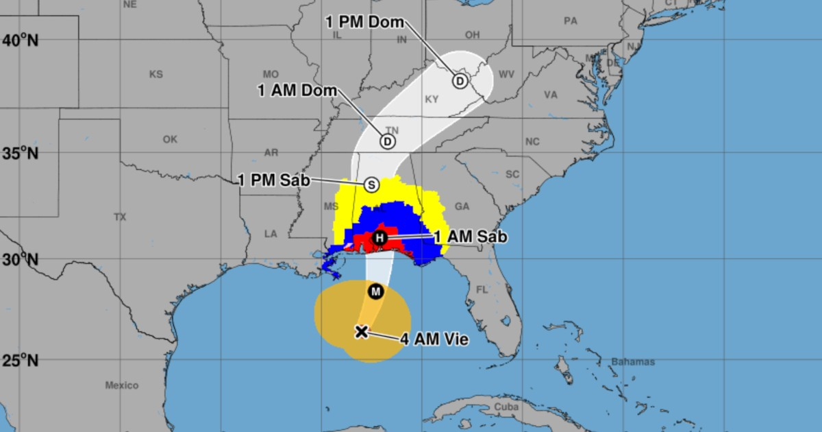
The hurricane Isaías strengthened during the early hours of this Friday, October 9, reaching maximum sustained winds of 175 km/h in the Gulf of Mexico, while its tropical storm-force winds extend up to 295 kilometers from the center. The National Hurricane Center of the United States (NHC) warned of a rapid deterioration of weather conditions on the northern Gulf coast and urged immediate completion of preparations in areas under alert.
The public advisory number 11 from the NHC, issued at 4:00 a.m. on Friday in the Central Time Zone of the United States (09:00 UTC and 5:00 a.m. in Miami), confirms that Isaias remains a Category 2 hurricane, although it could reach Category 3 during the morning. This additional strengthening is a forecast, not an intensity that has already been observed.
Isaiah gains strength as it moves toward the U.S. coast
At the time of the advisory, the eye of the hurricane was located near 26.4 degrees north latitude and 88.0 degrees west longitude, approximately 320 kilometers south-southeast of the mouth of the Mississippi River and 590 kilometers north-northeast of Progreso, Mexico. It was moving northeast at 24 km/h and its minimum central pressure had dropped to 963 millibars.
Data from the hurricane hunter aircraft of the Air Force and the National Oceanic and Atmospheric Administration (NOAA) indicate that sustained winds have increased to 110 miles per hour, equivalent to about 175 km/h, with higher gusts. In the previous advisory, the NHC had them at 165 km/h.
The radius of hurricane-force winds extended up to 45 kilometers from the center, while tropical storm winds reached up to 295 kilometers from the eye. This latter figure corresponds to the maximum extent from the center in any direction, not to the total diameter of the storm or to an area of uniform winds.
The NHC expected that Isaías would turn north on Friday, approaching the northern Gulf coast by the afternoon and making landfall somewhere in the warning area during the night of Friday or in the early hours of Saturday, October 10. Although a slight weakening was anticipated before landfall, the agency emphasized that it would still be a dangerous hurricane.
Alert for waves of up to 2.1 meters
One of the most serious risks is the storm surge. According to the NHC, the water could rise between 1.5 and 2.1 meters above normally dry land in areas of the coast between Dauphin Island, Alabama, and Indian Pass, Florida, if the maximum sea rise coincides with high tide. Intense waves can exacerbate those floods.
Between Indian Pass and the Steinhatchee River in Florida, the forecast predicts storm surges of between 1.2 and 1.8 meters. In Mobile Bay and other sections of the coasts of Mississippi, Alabama, Louisiana, and Florida, coastal flooding is also anticipated, with varying heights depending on the location and the development of the cyclone.
The storm surge warning remains in effect from the mouth of the Mississippi River to the Suwannee River in Florida. Meanwhile, the hurricane warning covers the area from Ocean Springs, Mississippi, to the boundary between Bay and Gulf counties in Florida. Tropical storm warnings are in place for adjacent areas of Louisiana, Mississippi, and Florida, as well as a surge watch between the Suwannee River and Yankeetown.
The meteorological center emphasized that this is a potentially deadly situation for residents of exposed coastal areas and urged compliance without delay with local evacuation and protection orders.
Rains of up to 380 millimeters and a tornado threat
Isaiah could bring rain accumulations of between 100 and 200 millimeters over the weekend in southern Alabama, the northwest of Florida—including the Panhandle and Big Bend regions—and southwestern Georgia. In isolated areas, particularly where persistent bands of precipitation form in Florida, amounts could reach up to around 380 millimeters.
For much of the rest of the southeastern United States, rainfall is forecasted to be between 50 and 125 millimeters, with localized maxima of approximately 250 millimeters, especially in areas of the southern Appalachians and the Carolinas. The NHC warns of flash flooding, urban flooding, and river rises that could be significant in some places.
There is also a risk of tornadoes starting in the late afternoon hours on Friday in the coastal areas of Alabama, the Florida Panhandle, and the extreme southwest of Georgia. The threat could extend on Saturday to parts of eastern Alabama, Georgia, and the Carolinas. High surf, strong waves, and rip currents pose additional dangers for those in beaches and areas close to the shoreline.
Urgent preparations before the arrival of the hurricane
The NHC anticipates that tropical storm conditions will begin to be felt in the areas under warning in the coming hours, and that hurricane-force winds could arrive Friday night or early Saturday morning. The impact will not be limited to where the eye makes landfall: winds, rain, and flooding can affect territories far from the central path.
The intensification of Isaías updates the situation reported by CiberCuba in its previous information about the 165 km/h. The new information confirmed in advisory 11 includes an increase to 175 km/h, a decrease in central pressure to 963 millibars, and the maximum extent of tropical storm winds reaching up to 295 kilometers from the center.
The data for this news corresponds to advisory 11 from 09:00 UTC on October 9, 2026. As intensity, trajectory, and alerts can change, residents in threatened areas should follow the official updates from the NHC and the instructions from local emergency authorities.
Related videos:
Filed under: