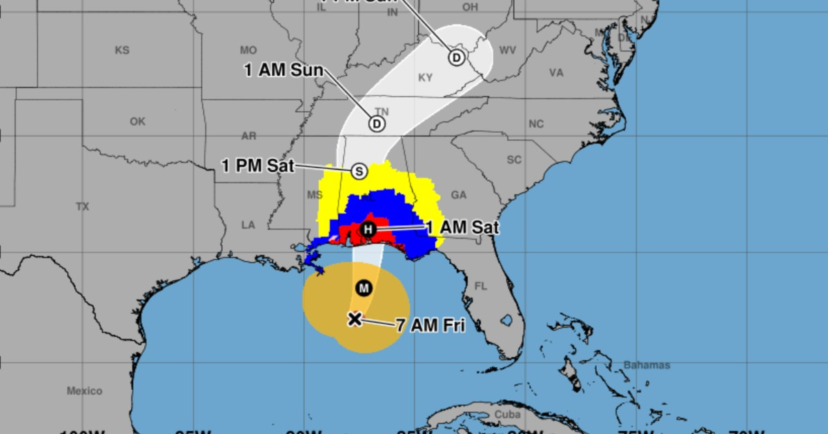
The National Hurricane Center (NHC) has revised its forecast for storm surge flooding upward in parts of northwest Florida and now anticipates up to 2.7 meters of water over land in the area from the Alabama-Florida border to Grayton Beach. This change is noted in the corrected intermediate bulletin 11A, corresponding to 7:00 a.m. CDT on this Friday, October 9.
The official bulletin from the NHC indicates a potential flooding of between 6 and 9 feet (1.8 to 2.7 meters) for that sector if the peak surge coincides with high tide. The figure describes the height of water over normally dry land, not the height of the waves. The corrected version of the report explicitly notes adjustments to the projected heights and the affected areas.
The new forecast exceeds the maximum of 7 feet (about 2.1 meters) recorded hours earlier in the 11th bulletin, as reported by CiberCuba. The NHC has now defined the coastal segments in greater detail, placing the highest value between the border of Alabama and Florida and Grayton Beach. The correction does not alter the current weather warnings and alerts.
Which areas face the greatest coastal flooding?
Between Dauphin Island, Alabama, and the Florida border, the NHC forecasts flooding of 4 to 6 feet (1.2 to 1.8 meters). Between Grayton Beach and Indian Pass in Florida, the estimate is 4 to 7 feet (1.2 to 2.1 meters); from Indian Pass to the Steinhatchee River, 4 to 6 feet (1.2 to 1.8 meters).
For the stretch between the Steinhatchee and Suwannee rivers, a forecast of 3 to 5 feet (0.9 to 1.5 meters) is expected, and between the Suwannee and Yankeetown, 2 to 4 feet (0.6 to 1.2 meters). From the mouth of the Mississippi River to Dauphin Island, as well as in Mobile Bay, the forecast is 3 to 5 feet (0.9 to 1.5 meters).
The agency warns that deeper flooding could occur in coastal areas where winds push water inland, accompanied by large and dangerous waves. The severity of the flooding depends on the alignment between the storm surge and the tidal cycle, which means it can vary significantly between nearby locations.
Isaiah is approaching with winds of 175 km/h
At 7:00 a.m. CDT (8:00 a.m. in Miami), the center of Isaias was located near 27 degrees north latitude and 87.7 degrees west longitude, approximately 390 kilometers south of Pensacola, Florida. It was moving north-northeast at 24 km/h, with maximum sustained winds of 175 km/h and a minimum central pressure of 958 millibars, according to observations from the NHC and a reconnaissance aircraft from the U.S. Air Force Reserve.
At that moment, Isaías was at the upper limit of category 2. The NHC considered it likely to reach category 3 by Friday morning and to remain a dangerous hurricane as it made landfall on the northern Gulf Coast, expected during the night of Friday or in the early hours of Saturday, October 10th.
Hurricane-force winds extended up to 45 kilometers from the center, while tropical storm winds reached up to 295 kilometers in distance. The NHC expected Isaias to turn north on Friday and approach the U.S. Gulf Coast that same afternoon.
A tropical storm surge warning remains in effect from the mouth of the Mississippi River to the Suwannee River, as well as a hurricane warning from Ocean Springs, Mississippi, to the boundary between Bay and Gulf counties in Florida. There are also tropical storm warnings from the boundary between Jefferson and Plaquemines parishes in Louisiana to west of Ocean Springs, and from east of the Bay and Gulf county line to the Aucilla River in Florida. Additionally, a surge watch is in effect between the Suwannee River and Yankeetown.
Rainfall of up to 380 millimeters and risk of tornadoes
The 11A bulletin forecasts between 100 and 200 millimeters of rain over the weekend in southern Alabama, the northwest, and the Big Bend region of Florida, as well as in southwestern Georgia. Isolated accumulations could reach around 380 millimeters, especially in areas affected by persistent bands of precipitation in the Panhandle and Big Bend of Florida.
In other areas of the southeastern United States, accumulations of 50 to 125 millimeters are expected, with localized maxima close to 250 millimeters, especially in the southern Appalachians and the coastal regions of the Carolinas.
The rains could cause sudden and urban flooding, with considerable impacts in southern Alabama, northwest Florida, and southwestern Georgia. River flooding is also expected, some of which could be significant.
The NHC warns of a risk of tornadoes from late Friday afternoon into the night in the coastal areas of Alabama, northwest Florida, and southwestern Georgia. On Saturday, the threat will continue in parts of eastern Alabama, the Florida Panhandle, Georgia, and the Carolinas.
In addition, the swells generated by Isaías, which were already affecting western and northern areas of the Yucatán Peninsula, will extend toward the northern Gulf of Mexico. These conditions could lead to dangerous waves and potentially lethal rip currents.
The NHC urges residents in hurricane and storm surge warning areas to complete preparations in the coming hours and to follow evacuation orders from local authorities. Maps of areas threatened by coastal flooding can be viewed on the official NHC storm surge forecast page.
Related videos:
Filed under: