
Related videos:
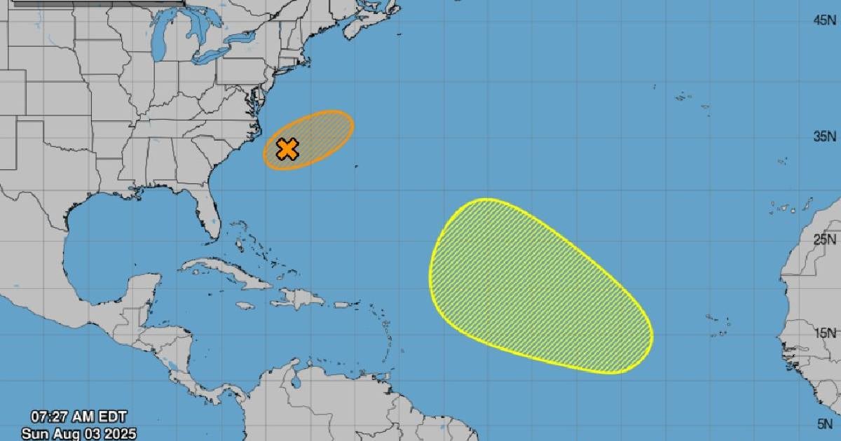
A new area of atmospheric instability in the western Atlantic, identified as AL95, is located about 290 kilometers off the coast of North Carolina and could develop into a depression or tropical storm in the next 48 hours
According to the latest report from the National Hurricane Center (NHC), the extratropical system remains over a stationary front with disorganized rain and thunderstorms, while it slowly moves toward the east-northeast, away from the U.S. coastline.
The environmental conditions are only marginally favorable, but enough for the NHC to give it a 50% chance of development in the coming hours.
Although it moves away from the continent, the weather uncertainty and structural fragility in many areas of the Caribbean require vigilance, especially if the system changes its behavior or indirectly influences other regional patterns.
On the other hand, a tropical wave still in Africa could become a threat next week. Although it currently shows no potential for development, models suggest it could gradually strengthen as it crosses the Central Atlantic heading west-northwest.
This second system has a low chance of formation over the next 48 hours, but the NHC gives it a 30% development potential in seven days.
Without signs of immediate strengthening, attention is focused on how it will evolve during its transit, especially along its classic route toward the Caribbean.
Both phenomena serve as reminders that the hurricane season is active and does not wait for anyone. Although current forecasts do not indicate a direct threat to Cuba, experience forces us to remain vigilant.
During the current hurricane season, several significant events have been recorded in the Atlantic and the Caribbean, reflecting an active behavior of the atmospheric system.
One of the most significant moments was the formation of Chantal, the third tropical storm of the year, which marked an early milestone in the season's evolution due to its rapid development as a named phenomenon.
In mid-July, Colorado State University (CSU) updated its forecast for the 2025 Atlantic hurricane season, showing a slight reduction in the figures while maintaining the alert for activity above the historical average.
The new report estimated a total of 16 named storms, 8 hurricanes, and 3 major hurricanes (category 3 or higher).
This represents a slight adjustment from the June forecast, when 17 storms, nine hurricanes, and four major hurricanes were anticipated.
The July review takes place in a context where Atlantic Ocean temperatures remain significantly above average, which promotes the formation of cyclones, and the absence of the El Niño phenomenon is anticipated, as it usually helps to weaken or disrupt these formations.
Frequently Asked Questions about the 2025 Hurricane Season and Its Potential Impact
What is the probability of a cyclone forming off the coast of North Carolina?
The National Hurricane Center (NHC) has given a 50% chance of development in the next 48 hours for the system identified as AL95, which is located about 290 kilometers off the coast of North Carolina. This system could become a depression or tropical storm as it moves toward the east-northeast.
What is expected from the 2025 hurricane season in the Atlantic?
Colorado State University (CSU) has forecasted that the 2025 hurricane season will be more active than usual, with 16 named storms, 8 hurricanes, and 3 major hurricanes. This forecast is based on above-average Atlantic ocean temperatures and the likely absence of the El Niño phenomenon, which favors the formation of cyclones.
What is the potential impact for Cuba during this hurricane season?
Although there are currently no direct threats to Cuba, experience suggests that vigilance is crucial due to the country's structural vulnerability and the possibility of indirect impacts from systems developing in the Atlantic. Furthermore, an active season is anticipated that could affect the Caribbean region.
What other areas are being monitored for potential cyclonic development?
In addition to the AL95 system off the coast of North Carolina, a tropical wave still over Africa is also being monitored. Although it currently has a low chance of development in the next 48 hours, it could gradually strengthen as it crosses the central Atlantic.
Filed under: