
Related videos:
The hurricane Erin, currently a category 2, continues to strengthen and expand its reach in the western Atlantic, which will cause dangerous surf although it will not make landfall in the United States, according to specialists.
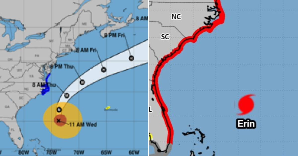
According to Local 10 News, it is currently located about 475 miles east-southeast of Florida, with maximum winds of 177 km/h (110 mph) extending over 160 kilometers from its center, a magnitude rarely seen in the history of the Atlantic basin.
Although it will not fully impact the continental territory, the effects of Erin are already being felt. On the social media platform X, the National Hurricane Center (NHC) warned that dangerous swells and rip currents will affect the entire east coast, from Miami to Massachusetts, where several beaches have been closed as a precaution.
In North Carolina, especially in the Outer Banks, moderate to severe flooding is expected with Thursday's high tide, along with waves of up to six meters (20 feet) in the coastal area and significant erosion of dunes and beaches.
A tropical storm warning is in effect for the North Carolina coast north of Morehead City—including the Outer Banks and the inlets of Pamlico and Albemarle—as well as for the Atlantic coast of Virginia, including Virginia Beach. Bermuda, for its part, remains under watch for possible storm-force winds in the coming hours.
Erin, an "extraordinary" hurricane
According to Local 10 News, several meteorologists emphasize that Erin is unusually large and powerful for a system so close to the U.S. Its central pressure is more typical of a category 4 hurricane, although its winds correspond to category 2.
In the satellite record, only cyclones like María (2017), Irma (2017), Sandy (2012), or Igor (2010) exhibited comparable characteristics. Additionally, nearby buoys have already reported wave heights of up to 12 meters (40 feet) offshore, with projections that some may exceed 30 meters (100 feet) in open water.
Despite the magnitude of the phenomenon, the U.S. is spared a direct catastrophic impact, although the event will be marked as one of the most extensive and high-risk coastal events in decades. Erin will begin to accelerate towards the northern Atlantic on Friday, but its effects on the waves and storm surge will persist for days along the U.S. coast.
Frequently asked questions about Hurricane Erin and its impact on the East Coast of the U.S.
What are the effects of Hurricane Erin on the East Coast of the United States?
The hurricane Erin will not make landfall in the United States, but it will cause dangerous surf and rip currents along the entire East Coast, from Miami to Massachusetts. Swimmers are advised to follow the instructions of lifeguards and local authorities to avoid risks.
Why is Hurricane Erin considered "extraordinary"?
The hurricane Erin is deemed "extraordinary" due to its unusual size and intensity, featuring a central pressure typical of a category 4 hurricane, although its winds correspond to category 2. Its width, rarely seen in the western Atlantic, and the effects of its waves make it remarkable in the region's history.
Which regions are under warning or watch due to Hurricane Erin?
North Carolina and Virginia are under a tropical storm warning, including areas such as the Outer Banks and Virginia Beach. Additionally, Bermuda is under watch for possible storm-force winds in the coming hours.
Filed under: