
Related videos:
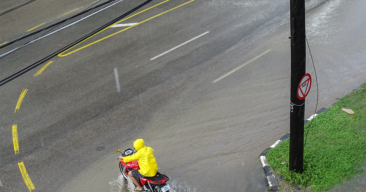
Intense rains and thunderstorms are expected in much of the Cuban territory starting Thursday afternoon, with the possibility of severe episodes lasting into the night.
According to a report this Thursday on Facebook by meteorologist Raydel Ruisánchez, an increase in cloud coverage is expected from the early hours of the afternoon, accompanied by showers and thunderstorms, especially along the northern coast and in areas of the interior of the western and central regions.
The specialist warned that these rainfalls could be strong and intense in certain areas, continuing until the evening.
The situation is due to the presence of a trough over the Florida Straits and another in the Gulf of Mexico, which generate a high moisture content throughout the atmosphere, combined with daytime heating.
Ruisánchez recommended that the public act with caution, avoid exposure to electrical discharges, and refrain from crossing flooded areas.
In another post also made on Facebook this Thursday, meteorologist Ruisánchez noted that a tropical wave in the eastern Atlantic has been designated as Invest #91L by the National Hurricane Center.
The current conditions are favorable for the development of a tropical depression in the coming days.
The system will shift westward and could position itself to the east of the Caribbean next week.
However, he warned that it is still too early to determine the possible impacts in the region, as 91L is about six or seven days away.
Due to its position and the time of year, he emphasized the need to maintain close surveillance over this system.
This Wednesday afternoon, intense rains were reported in the city of Bayamo, in the province of Granma, which caused floods in several streets and neighborhoods of the area, as well as interruptions to traffic and impacts on the local population.
According to meteorologist Elaine Báez, a specialist at the Provincial Meteorological Center, a total of 87.8 millimeters of rain was recorded in just two hours, between 5:30 p.m. and 7:30 p.m., along with significant lightning activity.
The event qualifies as locally intense rainfall, according to the official classification.
Last Sunday, Ruisánchez had warned about the presence of two troughs that would be creating unstable weather conditions over Cuba.
One of them was located in the southeast of the Gulf of Mexico and the other near the east of the country.
Both systems, combined with strong daytime warming and abundant humidity at different layers of the troposphere, would create a favorable environment for rain, showers, and thunderstorms, mainly in the western region and in areas of the interior and southern part of eastern Cuba, it warned on Facebook.
Frequently Asked Questions About the Weather in Cuba and Thunderstorms
Why are heavy rains and thunderstorms expected in Cuba?
The intense rains and thunderstorms are due to the presence of a trough over the Florida Strait and another in the Gulf of Mexico, which generate a high moisture content in the atmosphere, combined with daytime warming. These conditions favor the formation of clouds and storms over much of the Cuban territory.
What are meteorologist Raydel Ruisánchez's recommendations regarding storms in Cuba?
The meteorologist Raydel Ruisánchez advises the public to exercise caution, avoid exposure to electrical discharges, and refrain from crossing flooded areas during thunderstorms and heavy rainfall. It is important to follow these recommendations to minimize risks and ensure personal safety.
What impact could tropical wave Invest #91L have on the Caribbean?
It is still premature to determine the potential impacts of tropical wave Invest #91L in the Caribbean, as it is about six or seven days away. However, the current conditions are favorable for the formation of a tropical depression. It is important to maintain close monitoring of the system as it moves westward.
How does the El Niño-Southern Oscillation (ENSO) phenomenon affect the hurricane season in the Atlantic?
The neutral phase of the ENSO phenomenon does not restrict the development of cyclones as an active El Niño would. This, along with other climatic factors such as warmer than normal sea temperatures in the Atlantic and Caribbean, contributes to the Atlantic hurricane season being "above average," with a high probability of significant storms.
Filed under: