
Related videos:
An extensive area of low pressure that has been organizing in the center of the Caribbean Sea is about to become a tropical storm with a high potential for impact on several Caribbean islands, including Cuba.
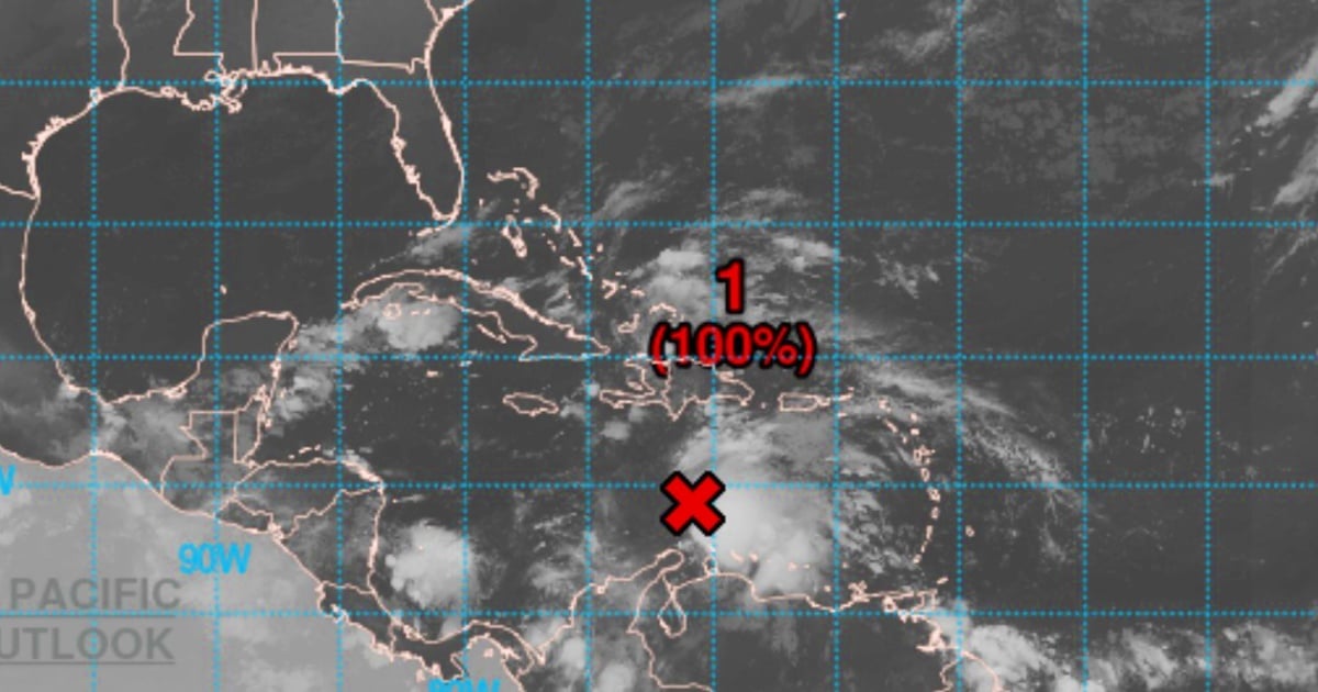
According to the latest bulletin from the National Hurricane Center (NHC), issued at 8:00 a.m. (Eastern Time), the tropical system classified as AL98 is expected to evolve this Tuesday into the tropical storm Melisa, the thirteenth of the current hurricane season.
According to weather models, Cuba is within the range of probable trajectories, which increases the likelihood that the country will experience heavy rains, strong winds, and flooding in the coming days.
The forecasts from the Canadian model (GEPS) show several scenarios that include a possible direct impact on the island, with a minimum pressure estimated at up to 982 millibars, suggesting a strong tropical storm or even a hurricane.
Latest satellite, radar, and surface observations reveal that the system now has a well-defined center, a key feature in the transition from a low pressure area to a tropical storm.
Additionally, it is already generating sustained winds of up to 45 miles per hour (72 km/h), a level that exceeds the minimum threshold required for classification as a tropical storm (39 mph or 63 km/h).
The forecast indicates that this phenomenon is slowing down, which could allow for further intensification in warm waters and under favorable atmospheric conditions.
The slow movement also increases the risk of prolonged rainfall over island and coastal regions.
Alert for Cuba and other islands in the Caribbean
The NHC warns that people in Puerto Rico, Hispaniola (Dominican Republic and Haiti), Jamaica, and Cuba should stay informed and closely monitor the progress of the system.
Although its exact trajectory and evolution have not yet been fully defined, eastern Cuba could be directly in the path of this system over the coming days, as clearly reflected by one of the models released in recent hours.
The potential for heavy rain and flooding, strong winds, and high waves could lead to dangerous conditions starting later this week.
The meteorological and civil protection authorities will need to assess potential preventive alerts in the coming hours.
What does José Rubiera say?
The popular Cuban meteorologist José Rubiera warned in recent hours that one of the most interesting weeks of the current hurricane season has just begun.
Rubiera discussed the different models, and stated that it is a "difficult forecast" due to the lack of consistency between the models, although both are justified, and explained why.
He indicated that we only need to stay very attentive in the coming hours to the evolution of the phenomenon and see what happens.
Mission of reconnaissance and marine forecasts
A mission by the Hurricane Hunters of the U.S. Air Force is scheduled to directly investigate the system throughout Tuesday. These flights are essential for confirming the internal structure of the cyclone and for improving forecasting models.
Additionally, the NHC recommends consulting the offshore forecasts from the National Weather Service for more details, especially concerning gale warnings and adverse conditions for navigation.
High probability of cyclonic development
The bulletin highlights that the probability of forming a tropical storm in the next 48 hours is 100%.
This is a situation with an imminent cyclonic risk, and the potential to escalate in intensity if atmospheric conditions allow it.
What to expect in the coming hours
The development of this system will be crucial in determining the level of threat to Cuba.
Although it is still early to determine whether it will reach hurricane status, preliminary models indicate a scenario that could affect the eastern region of the country with torrential rains, power outages, and urban and rural flooding.
The upcoming updates from the NHC will be crucial for monitoring the system's intensification and forecasting its path.
If it is confirmed as a tropical storm, it will be given an official name from the corresponding list for the 2025 season.
UPDATE:
Tropical storm Melissa formed this Tuesday in the Caribbean Sea. The National Hurricane Center reported on its official X account that it will begin alerts about Melissa starting at 11:00 AM Eastern Time (15:00 UTC).
The system is located at a latitude of 14.3 north and a longitude of 71.7 west, approximately 480 kilometers south of Port-au-Prince, Haiti.
Melissa has maximum sustained winds of 85 km/h, with higher gusts, and a minimum central pressure of 1003 millibars.
It is moving west at a speed of 22 km/h, and models indicate that it could gain strength over the next 48 hours as it progresses through the central Caribbean.
The NHC issued a hurricane watch for the southern peninsula of Haiti, from the border with the Dominican Republic to Port-au-Prince. Additionally, the government of Jamaica declared a tropical storm watch for the entire island.
Filed under: