
Related videos:
An impressive gust of wind of nearly 400 kilometers per hour —one of the highest recorded so far, according to meteorologists— was logged by a probe launched by hurricane hunters in the eye of Melissa on the morning of this Monday.
During a reconnaissance flight by a NOAA (National Oceanic and Atmospheric Administration) aircraft from the United States, a sensor recorded a wind gust of 388 km/h (241 mph) at an altitude of 709 feet at 8:55 a.m. EDT (Eastern Daylight Time), indicating the magnitude of this hurricane, which today escalated to category 5, the highest on the Saffir-Simpson scale, becoming the most powerful registered in the Caribbean in decades.
At around two in the afternoon this Monday, Melissa reached maximum sustained winds of 280 km/h, with higher gusts, and a central pressure of 906 mb (millibars), a threatening omen of the catastrophic impact it will have on Jamaica and Cuba.
After penetrating the eye of Melissa twice, the NOAA hurricane hunter plane N42RF (Kermit) investigating the system had to finally abandon its flight due to extreme turbulence in the southwest wall of the eye, noted American meteorologist Jeff Masters in an article published on the site Yale Climate Connections, a climate news service.
"This is only the fifth time that I am aware of the NOAA Hurricane Hunters having to abort a flight due to extreme turbulence (the others: Allen in 1980, Emily in 1987, Hugo in 1989, and Felix in 2007). I had the dubious honor of being the flight meteorologist on two of those flights, Emily in 1987 and Hugo in 1989," revealed the specialist.
On his part, Matthew Cappucci, also a meteorologist and atmospheric scientist, reported the event on social media and stated: “This is extremely rare (...) Airplanes are designed to withstand severe turbulence and extreme conditions. Melissa is a true monster.”
A U.S. Air Force hurricane hunter also revealed today that there were birds trapped in the eye of the hurricane.
Melissa, the third Category 5 hurricane in the Atlantic in 2025
Melissa exhibited a very rapid intensification over the weekend, since it was declared a hurricane on Saturday afternoon until this Monday, when it reached category 5.
Today it has continued to slowly advance over the Caribbean Sea and has started moving northwest, generating strong swells with waves ranging from 2.5 to 4 meters in southern Cuba, particularly off the coasts of Granma, Santiago de Cuba, and Guantánamo.
The Tropical Cyclone Warning No. 16, issued at 6 p.m. this Monday by the Institute of Meteorology of Cuba (INSMET), indicates that Melissa remains at category 5, and its maximum sustained winds and central pressure make it extremely dangerous.
The strong swells that are already affecting the southern coastline of eastern Cuba are causing flooding ranging from light to moderate in low-lying coastal areas. Maritime conditions will continue to deteriorate as the weather system approaches Cuba, experts warned.
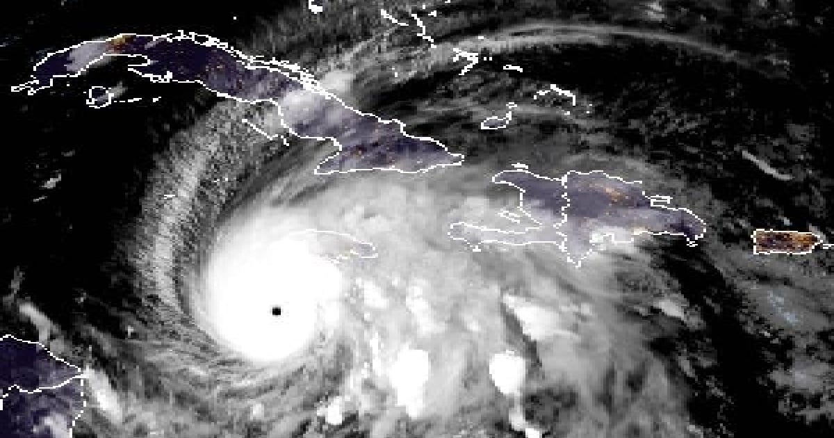
At six in the evening, the eye of the hurricane was estimated to be at 16.7 degrees north latitude and 78.4 degrees west longitude, about 215 kilometers southwest of Kingston, Jamaica, 350 kilometers south-southwest of Cabo Cruz in Granma province, and 460 kilometers southwest of the city of Santiago de Cuba.
The National Hurricane Center (NHC) forecasted on Monday that Melissa will bring two days of relentless torrential rain to Jamaica, eastern Cuba, and Haiti, with the possibility of catastrophic flooding.
The meteorologist José Rubiera warned that Melissa is a “gigantic” and “monstrous” Category 5 hurricane that will cross Jamaica between the night of this Monday and the early hours of Tuesday.
In the latest update on his Youtube channel, the expert warned that after passing over Jamaican territory, the hurricane could be caught by a trough and accelerate towards the eastern part of Cuba as a highly intense cyclone—possibly category 4 or 3—between Tuesday night and early Wednesday morning.
The 2025 hurricane season in the Atlantic has had a total of 13 named storms so far, five hurricanes, and four major hurricanes. Melissa is the third Category 5 hurricane, following Erin (August) and Humberto (September), making 2025 the second year with more than two hurricanes of that category recorded in the Atlantic.
Filed under: