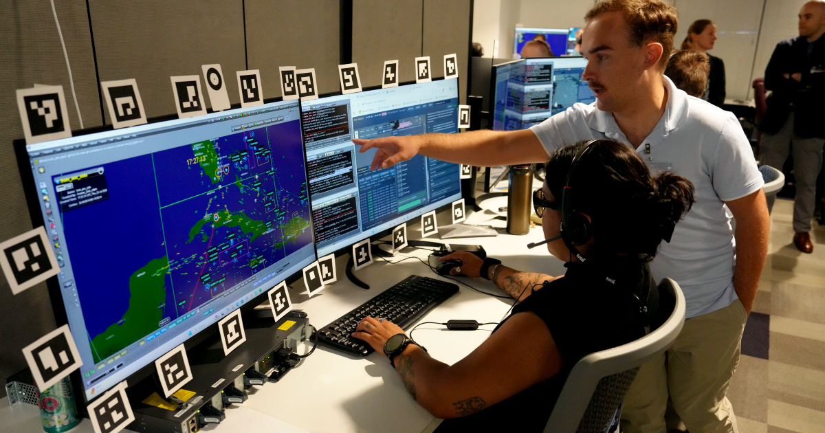
It was not just a map of Cuba.
A detailed review of the photographs published on the official site of the United States Space Force reveals that the screens used during the DASH military experiment displayed a complex tactical scenario over Cuba and the Caribbean, featuring numerous symbols, identifiers, tracks, and delineated operational areas.
The same geographic environment also appears in various workstations and photographs from the experiment, in which U.S. military personnel tested battle management applications and artificial intelligence tools designed to later transfer their capabilities to classified combat networks.
What exactly is represented by what is displayed over Cuba is something that the official information does not explain.
Cuba covered in symbols on the screens
The photograph that provides the most detail shows a member of the Air Force in front of several monitors. On the main screen, Cuba is at the center of the map, situated between the Yucatán Peninsula, Florida, the Bahamas, and Hispaniola.
On the island and its surrounding waters, dozens of symbols and identifiers can be seen, lines crossing different areas of the Caribbean, and various boxes delineating sectors of the scene.
Highlighted markers also appear on certain points and numerous elements identified by codes or names. In the top left corner of the application, it clearly reads “HIGHWAY2,” seemingly associated with the scene displayed on the screen.
The photograph also reveals names of Cuban localities and a particularly high concentration of operational information about Cuba and its surroundings.
A red label located in the central area of the island seems to contain the reference "SAMS", although the resolution of the published photograph does not allow for sufficient certainty in reading that.
The acronym SAM is commonly used in English military terminology to refer to surface-to-air missile. However, even if a higher resolution version confirmed that inscription, the image alone would not allow us to conclude that it represents actual sites of Cuban air defense systems.
It doesn't appear in a single station
Another relevant element arises when comparing the photographs to one another.
The map of Cuba and the Caribbean appears in different workstations and before various participants of DASH, although with variations in the area displayed and the level of zoom.
In an image, two air battle managers work in front of several monitors while one of them points at the screen. Cuba is once again clearly recognizable and is surrounded by numerous interface elements.
In another photograph, different participants are observing a screen displaying the same type of mapping and symbology. Other shots of the room show similar applications running simultaneously at different stations.
Overall views suggest that Cuba's presence is not limited to an isolated photograph taken accidentally when someone had a map of the region open. The island is part of the geographical environment displayed in various settings during the tests.
However, that does not allow us to determine what role Cuba played within the scenario.
What system were they using?
The captions published by the U.S. authorities help to answer another of the questions raised by the images.
In one of them, Colonel John Ohlund, director of the multifunctional team of the Advanced Battle Management System (ABMS), is seen explaining the operation of what the official description explicitly identifies as a "battle management application developed by the industry".
DASH —short for Decision Advantage Sprint for Human-Machine Teaming— was an experiment led by the multifunctional team of the Air Force's ABMS, in collaboration with the Air Force Research Laboratory, the United States Space Force, and the 805th Combat Training Squadron.
The tests took place in Las Vegas and utilized an unclassified environment that allowed for the rapid incorporation of commercial technologies.
But the intended destiny for the developed capabilities goes beyond the laboratory.
The Air Force explained that the architecture was designed from the outset to ensure that validated artificial intelligence tools could be securely transferred to classified command and control networks used by U.S. forces.
AI for faster combat decision-making
The goal of DASH is to integrate human operators and artificial intelligence to process large amounts of information and accelerate military decision-making.
The Air Force Department maintains that this collaboration between humans and machines can significantly reduce the times of the so-called "joint attack chain".
“Our goal is to quickly put the most advanced capabilities in the hands of the joint force,” explained Lieutenant Colonel Corey Ellsworth, head of integration for the ABMS multifunctional team.
Ellsworth noted that the system was designed so that, once a capability is validated, it can transition to classified networks where aviators and Space Force members could use it during a high-intensity conflict.
In DASH, Major Erik Murdock from the Space Force also participated, serving as the head of the Operations Division of the 57th Squadron of Space Aggressors.
The name and mission of that unit do not allow us to conclude that Cuba was representing the adversary in the experiment. The information published about DASH does not establish that relationship.
Were they simulating an operation against Cuba?
The photographs pose that question, but the available information does not allow for an affirmative response.
Neither the Department of the Air Force nor Space Force publicly identified Cuba as a target of the experiment. They also did not explain what the symbols located over the island represent, whether the positions correspond to fictional or real elements, what "HIGHWAY2" means within the test, or why the Caribbean was chosen for the visible scene in the photographs.
Therefore, the images do not show that the United States was rehearsing an attack against Cuba, nor do the elements depicted correspond to real military targets on the island.
What they do allow to verify is something more limited, but relevant: during a U.S. battle management experiment using artificial intelligence, a geographical scenario centered on Cuba and the Caribbean, adorned with operational symbolism, was utilized at different stations.
A detail that becomes significant given the current regional context
The images were taken during a period of heightened U.S. military activity in the Caribbean and significant tensions between Washington and Havana following the capture of Nicolás Maduro in Venezuela on January 3rd.
During 2026, Southern Command has conducted exercises in the region such as FLEX2026, which incorporated artificial intelligence, drones, and autonomous systems. Senior U.S. military officials have also visited the Guantanamo Naval Base, whose operational and logistical importance has been publicly emphasized by Southern Command itself.
Donald Trump, for his part, has made several statements about Cuba in recent months following the U.S. operation in Venezuela. In July, when asked about the possibility of a similar action against the island, he stated that the United States would have the capacity to do so, although he did not announce a military operation against Cuba.
None of these events demonstrate that the DASH scenario is connected to U.S. military plans regarding the island.
But that context explains why photographs now gain additional relevance: as Washington develops new capabilities in artificial intelligence, command and control, and autonomous systems, Cuba repeatedly emerges as the geographical center of one of the scenarios publicly showcased during those tests.
The question left open by the official images remains the same: what exactly does the scenario depicted over Cuba represent and why was the island chosen for these maps.
Related videos:
Filed under: