
Related videos:
On the afternoon of this Saturday, Tropical Storm Fernand formed in the waters of the Atlantic.
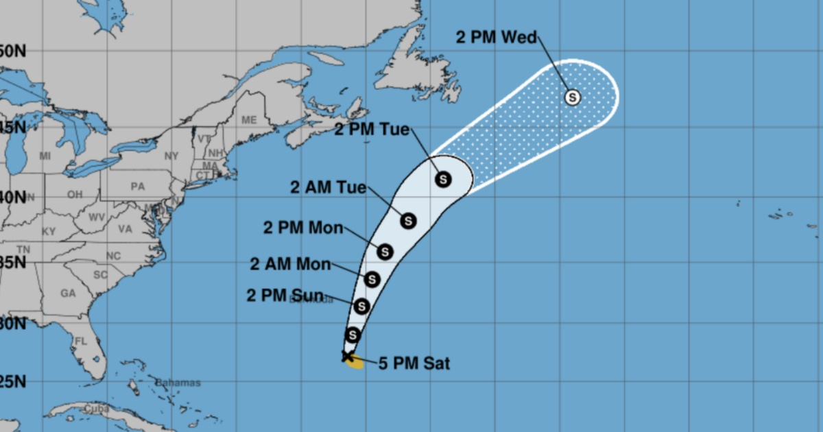
The meteor is located in the southwestern Atlantic, 655 kilometers from Bermuda, reported the National Hurricane Center of the United States (NHC).
The report indicates that Fernand has sustained winds of 65 kilometers per hour and could reach hurricane status on Monday before beginning to weaken on Tuesday.
"A movement toward the north-northeast is anticipated at a steadily increasing forward speed over the next two days, followed by a turn to the northeast. In the forecasted path, Fernand is expected to move well east of Bermuda and across the open waters of the subtropical North Atlantic," states the first bulletin from the NHC.
This is the sixth named storm of the season in the Atlantic.
The NHC is also monitoring a tropical wave located about 1,045 km east of the Windward Islands, which continues to produce rain and thunderstorms in the region.
According to weather reports, the system is moving swiftly to the west at 32-40 km/h, and is expected to cause heavy local rains and gusty winds in some islands over Sunday and Monday.
The National Hurricane Center (NHC) indicates that the likelihood of cyclonic development for this tropical wave is low, at 20% both over the next 48 hours and in the following seven days.
The Atlantic hurricane season, active from June 1 to November 30, reaches its climatological peak in September. Experts remind us that the current conditions—warm waters, low wind shear, and high humidity—are conducive to the formation of cyclones.
It is recommended that the population continuously monitor official bulletins and follow the instructions of local authorities in the event of any eventuality.
Frequently Asked Questions about Tropical Storm Fernand and the 2025 Hurricane Season
Where is tropical storm Fernand currently located?
Tropical Storm Fernand is located in the southwestern Atlantic, 655 kilometers from Bermuda. It is expected to move to the north-northeast and then turn to the northeast, staying well east of Bermuda.
What is the forecast for the development of Fernand?
Fernand is expected to strengthen and become a hurricane on Monday, and then begin to weaken on Tuesday. Its path is forecasted to remain over the open waters of the subtropical North Atlantic.
What other tropical formations are being monitored in the Atlantic?
In addition to Fernand, the National Hurricane Center (NHC) is monitoring a tropical wave located about 1,045 kilometers east of the Windward Islands. This wave has a low probability of tropical development at 20% in the coming days, but it may produce heavy rain and gusty winds in some islands.
How does the current climate affect the formation of cyclones in the Atlantic?
Current conditions in the Atlantic —such as warm waters, low shear, and high humidity— are conducive to cyclone formation. This increases the likelihood of an uptick in cyclonic activity during the season, which peaks climatologically in September.
Filed under: