
Related videos:
The National Hurricane Center (NHC) warned that the tropical storm Melissa is close to hurricane strength and could undergo a rapid intensification process this weekend, with a scenario of floods and landslides posing a threat to life in Jamaica and southern Hispaniola.
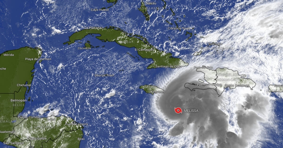
At 11:00 am this Saturday, the center was located at 16.5°N, 75.1°W, 155 miles (245 km) southeast of Kingston and 235 miles (375 km) southwest of Port-au-Prince, with maximum sustained winds of 70 mph (110 km/h), moving very slowly toward the west-northwest (1 mph/2 km/h) and a minimum pressure of 982 mb.
The tropical storm force wind field extended up to 125 miles (205 km) from the center.
The NHC maintains a hurricane warning for Jamaica and a hurricane watch along with a tropical storm warning for the southwest peninsula of Haiti, from the border with the Dominican Republic to Port-au-Prince.
In its projected path, the center of Melissa would pass near or over Jamaica between the weekend and the beginning of next week, with the possibility of being near or over the eastern part of Cuba by the middle of the week.
The agency added that watches could be issued for portions of eastern Cuba later on, and urged Haiti, the Dominican Republic, eastern Cuba, the southeastern and central Bahamas, and the Turks and Caicos to closely monitor the system's development.
The most dangerous component of the event will be the extreme and persistent rain.
The official forecast estimates accumulations of 15 to 25 inches in Jamaica and in the south of Hispaniola by Wednesday, with local maxima of 35 inches in eastern Jamaica and in the Tiburón Peninsula (Haiti).
The NHC warns of flash flooding and landslides with the possibility of catastrophic impacts in these areas.
For the east of Cuba, 5 to 10 inches are expected, with peaks of 15 inches until Wednesday, enough to cause flash floods and landslides in saturated slopes; however, totals beyond Wednesday remain uncertain.
In addition to the rain, the threat of a storm surge is concerning. The NHC indicates that a life-threatening surge is becoming increasingly likely along the southern coast of Jamaica by the end of the weekend or early next week, with heights of 7 to 11 feet above ground level, especially near and east of the point where the center of Melissa makes landfall.
That push from the sea will bring large and destructive waves. There is also potential for significant swell on the southeast coast of Cuba at the beginning of next week, while the waves generated by the cyclone will affect Hispaniola, Jamaica, and eastern Cuba in the coming days.
Regarding intensity, reconnaissance aircraft from the Air Force Reserve and NOAA confirmed that sustained winds remain near 70 mph, but the NHC predicts that Melissa could become a hurricane later this Saturday and a major hurricane by Sunday, given the very favorable conditions over the central Caribbean.
Meanwhile, the very slow movement expected today and tomorrow will keep the rain bands affecting the same areas, increasing the risk of extreme accumulations before the shift that would take the system north and northeast between Monday and Tuesday.
Authorities are urging to expedite preparations in areas under warning and watch, and to follow local instructions as bulletins are updated.
Filed under: