
Related videos:
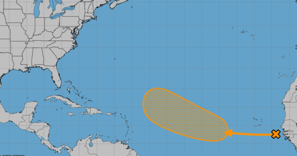
A tropical disturbance that has formed off the coast of Africa is moving toward the Atlantic and could gradually intensify over the course of the next week, according to weather reports.
According to the National Hurricane Center of the United States, at this moment, it does not pose a threat to land.
The tropical wave, anticipated for days, is developing over open water, and the prediction models agree that its initial trajectory will be mostly benign.
It is expected that by next weekend, when the system moves further north and west, it will be in a less hostile environment that could enhance its development.
Specialists warn that, although traditional models have lowered the likelihood of significant development, artificial intelligence projections maintain a more optimistic scenario for its strengthening.
The Google DeepMind hurricane model, in particular, is the one that shows the greatest potential for development towards the end of the week.
Despite these projections, experts emphasize that there are no signs of a direct land impact in the coming days.
However, they recommend monitoring the evolution of the system in case it shifts south and approaches the Caribbean islands.
The phenomenon occurs in a context of increasing cyclonic activity in the Atlantic, typical for this time of year.
Long-term forecasts suggest that over the coming weeks, additional disturbances could form with trajectories toward the west, although it is still too early to anticipate their behavior.
The Cuban meteorologist Christian Jesús Muñiz Carrillo warned that the hurricane season is entering its most active phase, as September is historically the month when the peak of hurricane formation occurs in the Atlantic.
According to what was explained, between 1950 and 2023, nine hurricanes have been recorded that made landfall in Cuba during the month of September.
He also recalled that during the first 20 days of September, the peak of the climatological season occurs.
The formation of cyclones this month tends to concentrate in the western tropical Atlantic, the Caribbean Sea, the Gulf of Mexico, and the central and western Atlantic.
Frequently asked questions about cyclonic formation in the Atlantic
What is the probability that the tropical disturbance will become a cyclone?
The probability of the tropical disturbance developing into a cyclone is 40%, according to the National Hurricane Center of the United States. However, projections from artificial intelligence, such as the Google DeepMind model, see a greater potential for development towards the end of the week.
How would this tropical disturbance affect the Caribbean islands?
For the moment, there are no signs of a direct land impact in the coming days. However, it is advisable to monitor the system's development in case it moves south and approaches the Caribbean islands.
Why is September a critical month for hurricane formation in the Atlantic?
September is historically the month when the peak of hurricane formation in the Atlantic occurs due to favorable climatic conditions such as high ocean temperatures and low wind shear. Between 1950 and 2023, nine hurricanes that made landfall in Cuba have been recorded during this month.
What are the factors that could promote the development of the tropical disturbance?
The factors that could favor the development of the tropical disturbance include a less hostile environment with warm ocean temperatures and low wind shear, as well as the presence of moisture in the region.
Filed under: